
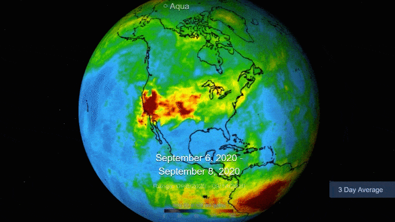
This visualization shows a three-day average of carbon monoxide concentrations from September 6-14 in the atmosphere over California due to forest fires. Higher gas concentrations appear as red and orange areas. Photo credit: NASA / JPL-Caltech
The observations from earth orbit show concentrations of the gas at high altitudes that are more than ten times the typical amounts.
NASAThe Atmospheric Infrared Sounder (AIRS) on board the Aqua satellite captured plumes of carbon monoxide from California forest fires last week. On September 14, 2020, 28 major forest fires broke out across the state. This includes the August Complex Fire, which began on August 17 and has since set more than 471,000 acres on fire. This makes it the largest fire ever recorded in California.
The animation shows three-day averages of carbon monoxide concentrations in the atmosphere between 6 and 14 September by 5 kilometers. The red and orange areas indicate regions with extremely high carbon monoxide concentrations greater than 350 ppm by volume (ppbv). The more normal background levels of carbon monoxide appear yellow and green with levels between 30 and 50 ppbv.
Carbon monoxide is released by the fires along with smoke and ash and is a pollutant that can remain in the atmosphere for about a month and be transported over great distances. At the altitude shown in these pictures, the gas has little influence on the air we breathe. However, strong winds can carry it down where it can significantly affect air quality. Carbon monoxide plays a role in both air pollution and climate change.
The intense heat of the forest fires threw the carbon monoxide high into the atmosphere and enabled it to be detected by the AIRS instrument. The jet stream then blew the carbon monoxide plume eastward over the United States and across the Atlantic.
In conjunction with the Advanced Microwave Sounding Unit (AMSU), AIRS records the infrared and microwave radiation emitted by the earth in order to obtain a three-dimensional view of the earth’s weather and climate. The two instruments work together and simultaneously make observations down to the earth’s surface. With more than 2,000 channels covering different regions of the atmosphere, the system creates a global three-dimensional map of atmospheric temperature and humidity, cloud amounts and heights, greenhouse gas concentrations and many other atmospheric phenomena. Launched into Earth orbit in 2002, the AIRS and AMSU instruments fly aboard NASA’s Aqua spacecraft and are managed by NASA’s Jet Propulsion Laboratory in Pasadena, California on behalf of NASA. JPL is a division of Caltech.
The latest carbon monoxide data and other information from NASA Earth observation missions can be found in the fully interactive Eyes on the Earth. The Recent Events feature allows you to examine geographically located satellite images of recent Earth events, including algal blooms and forest fires.