
October 1, 2020.
After a short break, a heat wave at the end of September enlivened the already brutal fire season 2020 in California.
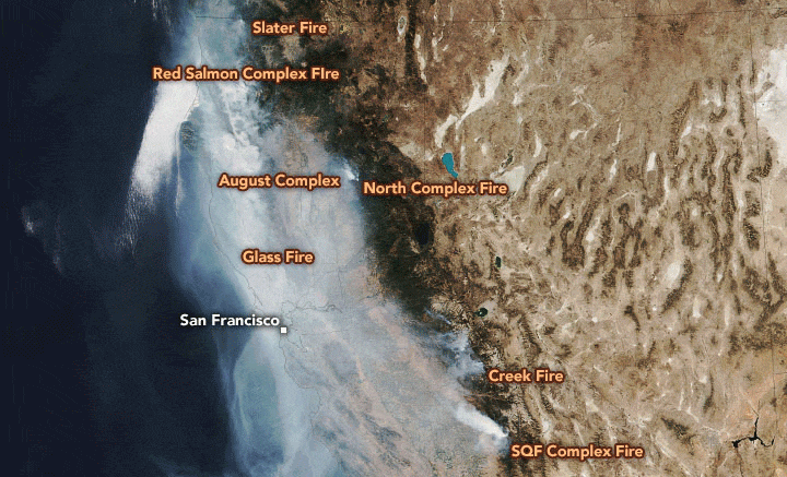
The Visible Infrared Imaging Radiometer Suite (VIIRS) on the NOAA-20 satellite captured this natural color image of the state on October 1, 2020. The volume of smoke emanating from the fires has been high in recent days and has spread over much of the state.
On the same day, the Environmental Protection Agency’s Airnow system reported that many sensors across the state had measured unhealthy (between 150 and 200 on the Air Quality Index) and dangerous (over 300 AQI) conditions in the past few days. In some cases, especially near the fires, sensors recorded AQI values that exceeded 1000.
California fires have charred more than 3.7 million acres since the start of the year, according to Cal Fire. Flames destroyed more than 8,000 buildings and claimed at least 31 lives. As of October 2, more than 50,000 people had been subjected to evacuation orders.
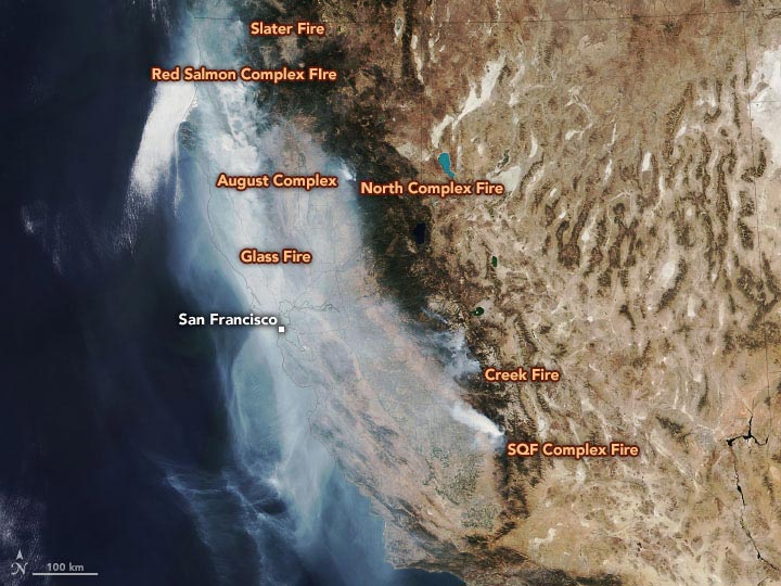
October 1st, 2020. (Click the picture for full details.)
Several fires are adding to the layer of smoke that currently hangs over the state. The most active and least controlled included the glass fire (6 percent included), the Red Salmon Complex (31 percent), the Creek (45 percent), the Slater (50 percent), the August Complex (51 percent), and the SQF complex (61 percent) and north complex (79 percent).
The August Complex, the largest recorded fire in California, had set fire to nearly 1 million acres by October 2. The North Complex Fire, which destroyed more than 2,315 buildings, was the fifth most destructive in history. The glass fire, currently the least controlled fire in California, devastated several vineyards and smothered the Bay Area with smoke.
Forest fire smoke contains a potent mixture of particles and gases that can pose a serious health risk. According to a recent analysis by researchers at the Stanford Center for Food Security and the Environment, poor air quality from fires in August and September 2020 likely contributed to more than 1,200 deaths and 4,800 additional hospital visits in California.
NASA Earth Observatory images by Joshua Stevens using VIIRS data from NASA EOSDIS / LANCE and GIBS / Worldview and the Joint Polar Satellite System (JPSS).

